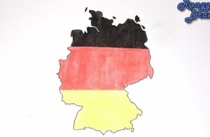
How to draw Germany (map) - How to draw Germany (map) with this how-to video and step by step drawing instructions. easy map drawing tutorial for beginners and children. Please see Germany drawing tutorial in the video below You can refer to Germany simple step by step drawing guide below Step 1: Gather Reference - https://htdraw.com/wp-content/uploads/2024/02/How-to-draw-Germany.jpg - https://htdraw.com/how-to-draw-germany-map/
How to draw Germany (map) with this how-to video and step by step drawing instructions. easy map drawing tutorial for beginners and children.

Find a reference map of Germany to use as a guide. You can use a printed map, an image from the internet, or a digital map on your computer or tablet.
Start by drawing the basic outline shape of Germany. Germany is located in Central Europe and has a distinctive shape that includes various borders with neighboring countries. Begin with a rough sketch using light pencil strokes.
Carefully outline the borders of Germany, paying attention to details such as curves and angles. Germany shares borders with several countries, including France, Switzerland, Austria, the Czech Republic, Poland, and Denmark.
Identify and draw some of the major geographic features of Germany, such as the Alps in the south, the Rhine River, and other significant rivers like the Elbe and the Danube.
If you're including Germany's coastline, such as along the North Sea or Baltic Sea, carefully outline it on your map. Germany's coastline includes various bays, estuaries, and peninsulas.
Mark some of the major cities on your map, such as Berlin, Munich, Hamburg, Frankfurt, and Cologne. You can represent them with small circles or dots, labeling each one with its name.
Add any other important details you want to include on your map, such as state boundaries (like Bavaria, Saxony, or Baden-Württemberg), national parks, landmarks, or significant cultural sites.
Once you have all the major elements in place, go over your drawing and refine any rough lines or shapes. You can darken the outlines with a pen or marker if you like, and erase any unnecessary pencil marks.
Finally, label your map with a title ("Germany"), a compass rose, and a scale if you want to add those details. You can also label the major geographic features, cities, and towns.
Review your map to ensure accuracy and make any final touch-ups or adjustments as needed. Congratulations, you've drawn a map of Germany!
Feel free to add more details or decorations to your map to make it your own. Drawing maps is a creative process, so don't be afraid to experiment and have fun with it!
- https://htdraw.com/wp-content/uploads/2024/02/How-to-draw-Germany.jpg - https://htdraw.com/how-to-draw-germany-map/

Please see Germany drawing tutorial in the video below
You can refer to Germany simple step by step drawing guide below
Step 1: Gather Reference Material
Find a reference map of Germany to use as a guide. You can use a printed map, an image from the internet, or a digital map on your computer or tablet.
Step 2: Draw the Basic Shape
Start by drawing the basic outline shape of Germany. Germany is located in Central Europe and has a distinctive shape that includes various borders with neighboring countries. Begin with a rough sketch using light pencil strokes.
Step 3: Outline the Borders
Carefully outline the borders of Germany, paying attention to details such as curves and angles. Germany shares borders with several countries, including France, Switzerland, Austria, the Czech Republic, Poland, and Denmark.
Step 4: Add Major Geographic Features
Identify and draw some of the major geographic features of Germany, such as the Alps in the south, the Rhine River, and other significant rivers like the Elbe and the Danube.
Step 5: Outline the Coastline (if applicable)
If you're including Germany's coastline, such as along the North Sea or Baltic Sea, carefully outline it on your map. Germany's coastline includes various bays, estuaries, and peninsulas.
Step 6: Include Major Cities
Mark some of the major cities on your map, such as Berlin, Munich, Hamburg, Frankfurt, and Cologne. You can represent them with small circles or dots, labeling each one with its name.
Step 7: Add Other Details
Add any other important details you want to include on your map, such as state boundaries (like Bavaria, Saxony, or Baden-Württemberg), national parks, landmarks, or significant cultural sites.
Step 8: Refine and Finalize
Once you have all the major elements in place, go over your drawing and refine any rough lines or shapes. You can darken the outlines with a pen or marker if you like, and erase any unnecessary pencil marks.
Step 9: Label Your Map
Finally, label your map with a title ("Germany"), a compass rose, and a scale if you want to add those details. You can also label the major geographic features, cities, and towns.
Step 10: Review and Touch Up
Review your map to ensure accuracy and make any final touch-ups or adjustments as needed. Congratulations, you've drawn a map of Germany!
Feel free to add more details or decorations to your map to make it your own. Drawing maps is a creative process, so don't be afraid to experiment and have fun with it!
You can see more map drawings:
- https://htdraw.com/wp-content/uploads/2024/02/How-to-draw-Germany.jpg - https://htdraw.com/how-to-draw-germany-map/
Nhận xét
Đăng nhận xét